6th Ave Homes Fort Worth House StoriesNo. 01

Fort Worth, Texas  ·  Holloway Addition, Block 4

1013 PoindexterA house on the street that used to be Pearl

Walk out the back door of this house and the live oak is right there — about seventy-five feet away, a short step past the back fence and across open park lawn. It is on the Texas A&M Forest Service's list of the Famous Trees of Texas, and it is the tree Tarrant County held its first election behind. Twenty-five feet of the ground between the house and that tree used to belong to this lot, until somebody signed it over to the City for $300 in 1958. Here's how all of it got from a surveyor's plat in 1911 to here. I pulled every bit of it out of county deed books, that plat, and an assessor's card somebody typed in 1938 — and every number on this page came off a document you can open and read yourself.

Built, per tax roll1924
Recorded owners since 1927Seven
Sq ft, 1938 assessor2,034
Sq ft, tax roll2,066
Lot, as platted 191150 × 125 ft
Lot today98 × 100 ft

It is for sale. If that is what you came for, the listing, the photographs and the floor plan are at the bottom of this page and you should go straight there. Everything in between is the part I think makes it worth buying.

Hand-lettered title block reading A Revised Map of Holloway's Addition to Fort Worth, Texas. Scale 1 inch equals 100 feet. 1911. Surveyed by Brookes Baker, Surveyor, Fort Worth, Texas.
Where the record starts: the title block of the 1911 revised plat, lettered by hand.

The Record

1911 — 2026
19117 March

Mrs. M. A. Holloway re-plats an addition that had been erased

The original Holloway's Addition had been undone. Its dedication was vacated by order of the Commissioners Court of Tarrant County, and for some years the subdivision existed only on paper that no longer meant anything.

On the seventh of March 1911, Mrs. M. A. Holloway — described in her own dedication as a feme sole, a woman holding property in her own right — signed a revised plat putting the streets back. Brookes Baker surveyed it. Block 4 got nineteen lots, fifty feet wide and a hundred and twenty-five deep. Lots 1 through 9 fronted Pearl Street. Pearl is Poindexter now.

Baker drew two things on that plat that were not lots. A well, on Block 4, Lot 1. And a small circle with a line running to it, labeled in his hand: Spring. It sits on Block 5, Lot 2, a short walk north of here, in what is now Traders Oak Park.
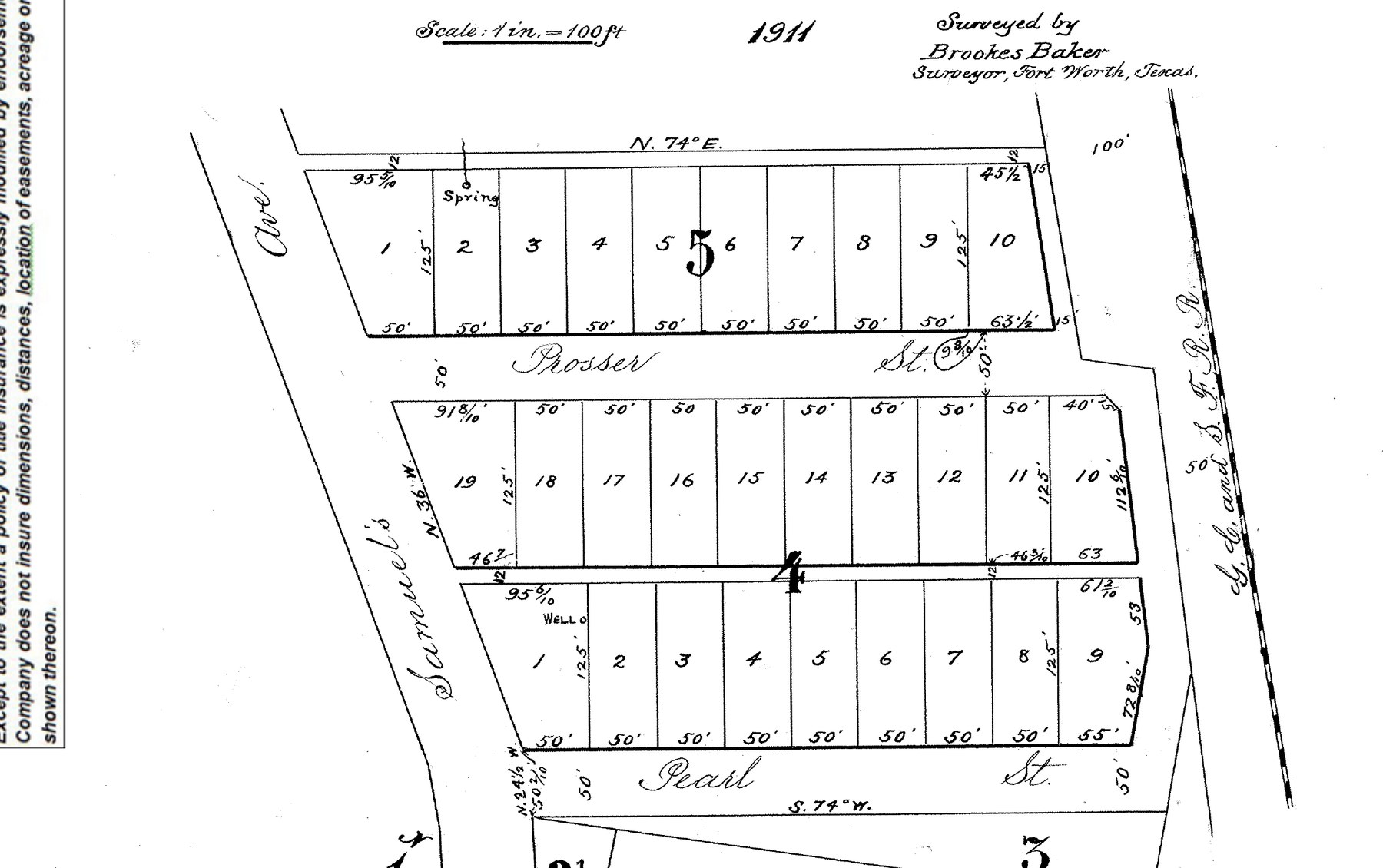
Detail of the 1911 revised plat showing Blocks 5, 4 and 3, with Prosser Street, Pearl Street, Samuel's Avenue, the G.C. & S.F. Railroad, a spring on Block 5 and a well on Block 4. Click to enlarge ↗
Blocks 5, 4 and 3, as revised in 1911. Scale 1 in. = 100 ft. Block 4, Lots 1–9 front Pearl Street; Lots 10–19 front Prosser. Pearl is Poindexter today. Prosser is gone. This house sits on Lot 5 and the east 48 feet of Lot 4 — the bottom row, fifth and fourth from the left.

Why she signed alone

That phrase in the dedication — feme sole — always had a reason behind it, and I found the reason in a cemetery four blocks from this front door.
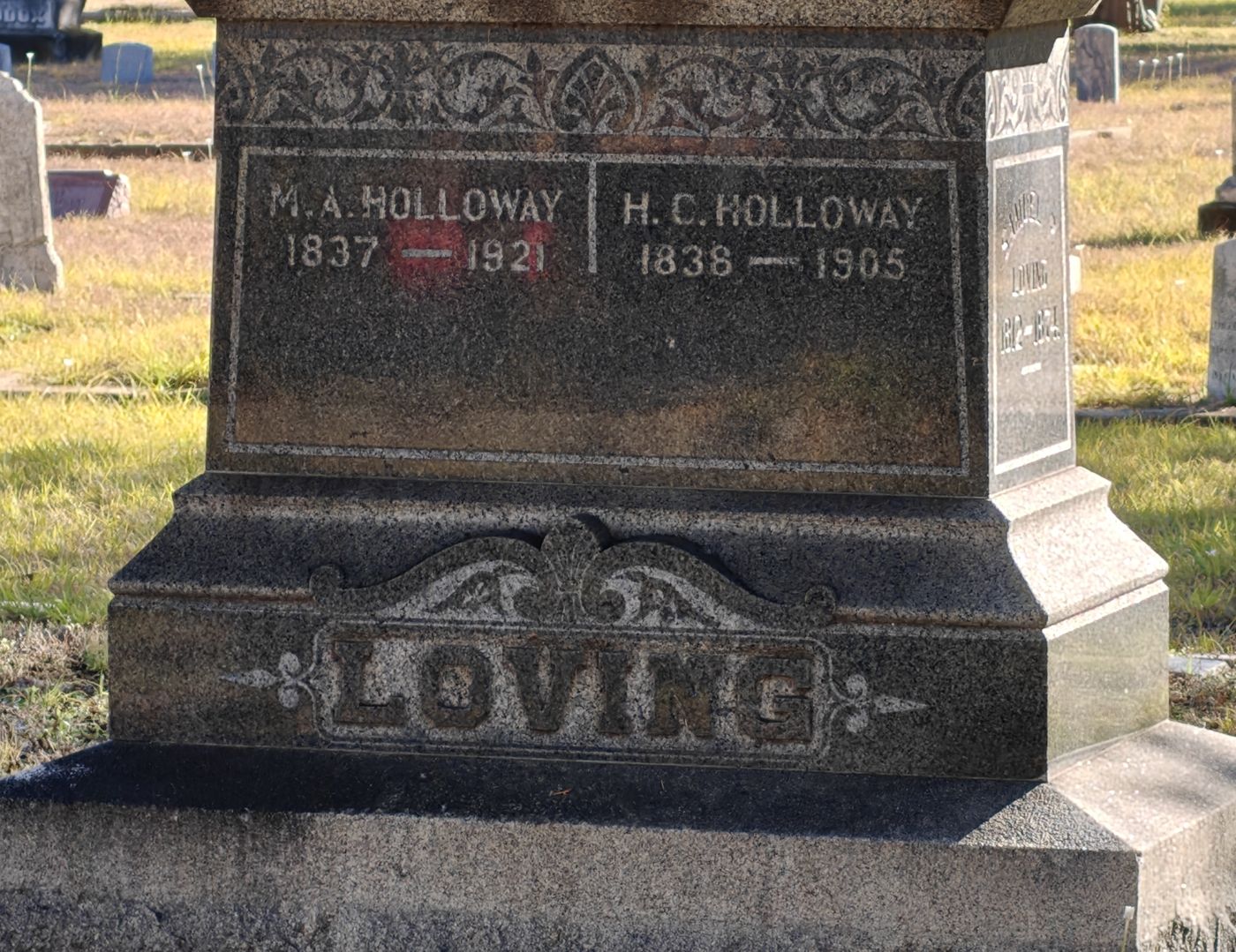
Granite monument in Pioneer's Rest Cemetery inscribed M. A. Holloway 1837-1921 and H. C. Holloway 1838-1905, on a base carved with the name Loving. Click to enlarge ↗
Pioneer's Rest Cemetery, 620 Samuels Avenue. M. A. HOLLOWAY, 1837–1921 and H. C. HOLLOWAY, 1838–1905, on a base carved LOVING. Photographed 5 October 2026.

H. C. Holloway died in 1905. Six years later his widow put her name on this plat, by herself, and re-made a subdivision the county had erased. She lived another ten years and was buried beside him.

So the ground this house sits on was laid out by a widow in her seventies, and she is lying four blocks south of it under a stone with both their names on it. I have not found a document that ties the stone to the signature — it is the same name, the same initials, the same neighborhood, and dates that fit exactly. On this page that is called very probably, not certainly. But I would put money on it.
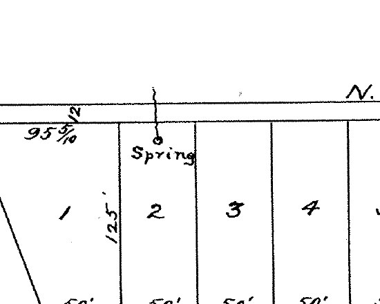
Close detail of the plat showing a small circle with a leader line, hand-labeled Spring, on Lot 2 of Block 5.
“Spring.” Block 5, Lot 2 — a circle, a leader line, and one word in the surveyor's hand.
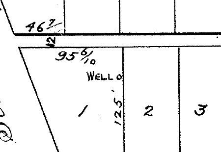
Close detail of the plat showing a small circle hand-labeled Well on Lot 1 of Block 4.
“Well.” Block 4, Lot 1 — four lots west of this house, on the same row.
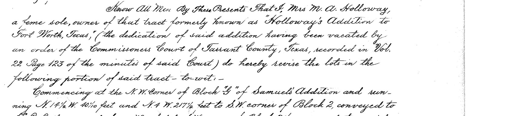
Handwritten opening of the 1911 dedication, beginning Know All Men By These Presents That I, Mrs M. A. Holloway, a feme sole.
The dedication, first lines. “…That I, Mrs. M. A. Holloway, a feme sole, owner of that tract formerly known as ‘Holloway's Addition to Fort Worth, Texas,’ (the dedication of said addition having been vacated by an order of the Commissioners Court of Tarrant County, Texas, recorded in Vol. 22 Page 123 of the minutes of said Court) do hereby revise the lots…”

Handwritten line reading Witness my signature this 7th day of March 1911, above the signature M. A. Holloway.
“Witness my signature this 7th day of March 1911.”  M. A. Holloway.

Source: A Revised Map of Holloway's Addition to Fort Worth, Texas, 1911. Surveyed by Brookes Baker, Surveyor, Fort Worth, Texas. Filed for record 2:50 p.m., 10 April 1911; recorded 10:00 a.m., 22 April 1911, A. J. Beavers, County Clerk. Acknowledged before Morgan Bryan, Notary Public. Tarrant County Plat Records.  ·  See the whole sheet ↗

1924

The house goes up

I have not found an original construction permit that would settle which of the two dates below is right. The year of record is 1924 — that is what the appraisal district carries today, and it is the figure anyone can look up.

The county's own older paperwork disagrees with it. When a Tarrant County assessor filled out a property card for this address in 1938, he wrote Built Year 1918. The house that stood next door then carries the same year on its own card. Two neighbouring houses in 1938, both recorded by the county as 1918 — which establishes a common build period, and nothing more than that. That house is gone. Nothing stands beside this one today.

So there are two dates, six years apart, both from the county. I publish 1924, because that is the record a buyer can verify. I print 1918 as well, because it is what the county’s own earlier paperwork says, and the house may be the older of the two.

Source: Tarrant County property assessment card, stamped DEC 15 1938. Abstract 1045, Map 7042.  ·  Tarrant Appraisal District, year built 1924.

1927October

A. C. Maclin buys the house for $4,750 — half of it in cash

The seller was Mobley & Delaney, Inc., a Texas corporation doing business in Fort Worth. C. L. Mobley signed as president; E. E. Aldridge attested as secretary.

The terms are on the face of the deed and they are not what a modern buyer would recognize. Four thousand seven hundred and fifty dollars, of which $2,485 was cash in hand — better than half. The balance, $2,265, rode on a vendor's lien note at eight per cent, due ninety days after its date.

Not a thirty-year mortgage. A three-month note.

And the description he bought is the description that sells today, word for word: Lot Five (5) and the east forty-eight (48) feet of Lot Four (4), in Block Four (4) of Holloway's Addition to the City of Fort Worth. That odd forty-eight feet has been attached to this house since at least 1927.

The Maclins would hold it for the next thirty-three years.

Typed deed record page reading Mobley and Delaney Inc. to A. C. Maclin, conveying Lot Five and the east forty-eight feet of Lot Four in Block Four of Holloway's Addition for $4,750. Click to enlarge ↗
Mobley & Delaney, Inc. to A. C. Maclin. Deed Record Volume 1001, Page 80.

Source: Tarrant County Deed Records, Vol. 1001, Pgs. 80–82. Acknowledged before Corydon A. Black, Notary Public, 25 October 1927. Filed for record 1 November 1927 at 11:49 a.m.; recorded 3 November 1927 at 11:35 a.m. Chester Hollis, County Clerk. The 1938 assessment card records the instrument as 10-17-27, $4,750.

1935& 1936

Twenty-one dollars and six cents

The assessor's card carries a line for delinquent taxes. For 1935 it reads $21.06.

The following year the family pulled a permit for $500 in repairs. In the middle of the Depression, on a house they had owned for nine years, they found five hundred dollars for it.

Source: 1938 assessment card, delinquent tax line and permit line.

193815 December

An assessor walks the property and writes down what he sees

This is the closest thing to a photograph of the house in 1938, and in some ways it is better than one. It is a stranger's plain description, made for tax purposes, with no reason to flatter anybody.

From the building card Built Year . . . . . 1918
Rooms . . . . . . . 7  ·  1 story
Main dwelling . . . 2,034 sq ft
Foundation . . . . . Piers
Roof . . . . . . . . Hip
Walls . . . . . . . Box / Frame / Weather Board
Heat . . . . . . . . Stove
Lighting . . . . . . Electric
Plumbing . . . . . . 5 fixtures — one bath
Floors . . . . . . . Hardwood
Construction . . . . Cheap
Condition . . . . . Fair

Seven rooms and one bathroom. Heated by stove. Graded Cheap and Fair by a man being paid to be unsentimental about it.

Orange Tarrant County building description card with printed checklists for class, roof, walls, heating, lighting, plumbing and condition, hand-marked, with a plat sketch of the house footprint at right and a December 15 1938 date stamp. Click to enlarge ↗
Building description card. Every line is a printed checklist the assessor ticked. At right, his sketch of the footprint fronting Poindexter, with two outbuildings. Date-stamped down the edge: DEC 15 1938.
Orange Tarrant County assessor's abstract of city property card showing the ownership record from Maclin A C in 1927 through O. W. Dixon in 1978, lienholders, and a delinquent tax record for 1935. Click to enlarge ↗
The ownership record. One card, six owners, fifty-one years — 1927 to 1978, each with its deed book and page. The delinquent tax line at the bottom reads 1935  ·  21 06.
Typed line at the top of the assessment card reading N 25 feet 4-5 to City 3247 100.
Typed across the top of the card, and the reason I went looking: N 25' 4-5 to City  3247  100. A book and a page. See 1958, below.
195413 April

The house passes to C. M. Maclin

Title moves to C. M. Maclin in the spring of 1954 — the second Maclin to hold it, twenty-seven years after the first. I have not documented the relationship between the two men, and until I have, this page is not going to claim one. The deed records a name and a date, and that is what is here.

Source: Tarrant County Deed Records, Vol. 2698, Pg. 429.

19588 September

The back twenty-five feet of the yard is signed over to the City

The 1911 plat drew these lots one hundred and twenty-five feet deep. The survey in hand today measures one hundred. For a long time the only trace of what happened to the difference was a single line typed across the top of a 1938 index card — a volume and a page.

That volume is Deed Record 3247. The page is 100. Here is what is on it.

Printed Texas standard warranty deed form, filled in by typewriter, conveying from C. M. Maclin and wife Geraldine Maclin to the City of Fort Worth for three hundred dollars. Click to enlarge ↗
Warranty Deed, Vol. 3247, Pg. 100. A Texas standard form, sold by Stafford-Lowdon Co. of Fort Worth, filled in on a typewriter.
The granting clause THAT We, C. M. Maclin and wife, Geraldine Maclin, of the County of Tarrant and State of Texas, in consideration of the sum of Three Hundred and no/100 ($300.00) DOLLARS to us in hand paid by the City of Fort Worth, a municipal corporation of Tarrant County, Texas, the receipt of which is hereby acknowledged, have Granted, Sold and Conveyed… all that certain lot, tract and parcel of land… described as follows:
Typed legal description reading: The north 25 feet of Lots 4 and 5, Block 4, Holloway's Addition to the City of Fort Worth, Tarrant County, Texas.
Twenty-eight words. That is the whole of it.

Three hundred dollars. Not a taking, not a condemnation — a deed, signed by both of them at Fort Worth on the eighth day of September, 1958.

Handwritten date line reading 8th day of September A.D. 1958, above the cursive signatures C. M. Maclin and Geraldine Maclin.
C. M. Maclin. Geraldine Maclin. Both signatures, on the line, in ink.

He had held the house four years when he signed. He died on the sixth of September, 1959 — one year and two days later.

You can walk out the back door of this house and stand on the ground he sold. It has been part of Traders Oak Park ever since.

Aerial view of the house and its back deck at left, the broad live oak of Traders Oak Park at right, open park ground between them, and the downtown Fort Worth skyline on the horizon. Click to enlarge ↗
The house, the tree and the city, in one frame. The house sits at left with its back deck facing the park; the live oak is the broad one at right. Everything past that back fence is Traders Oak Park — and the first twenty-five feet of it came off this lot on the eighth of September, 1958. Downtown Fort Worth on the horizon.
The rear deck of the house looking out over open lawn with mature trees beyond the back fence.
Standing on it.

Source: Warranty Deed, Tarrant County Deed Records, Vol. 3247, Pg. 100. Instrument No. 58670. Acknowledged before Joe S. Wooten, Notary Public in and for Tarrant County, 8 September 1958. Filed for record 23 September 1958 at 3:00 p.m.; recorded 30 September 1958 at 11:26 a.m. Melvin “Mel” Faulk, County Clerk, Tarrant County, Texas.

196016 November

The Maclins sell. Thirty-three years end.

Fourteen months after C. M. Maclin's death, Geraldine conveys the house to Elmer and Nellie Wheeler. It is the first time since 1927 that 1013 Poindexter is owned by someone not named Maclin.

She carried back the note herself — the assessment card records a deed of trust in favor of Mrs. Geraldine Maclin, dated 14 November 1960, for $5,100.

Source: Tarrant County Deed Records, Vol. 3503, Pg. 546.

19643 November

A trustee's sale

A trustee's deed conveys the house to Fort Worth Savings & Loan for $2,350 — thirty-seven years after A. C. Maclin bought it for $4,750.

Source: Trustee's Deed, Tarrant County Deed Records, Vol. 3996, Pg. 27.

1967& 1978

Two more hands

Dora Wright takes it from the savings and loan in July 1967. O. W. Dixon buys it in June 1978. After that the county's paper trail thins out and the house goes quiet for a long time.

Source: Vol. 4432, Pg. 497  ·  Vol. 7201, Pg. 249.

1978— 2008

The Dixons. Thirty years.

O. W. Dixon buys in June 1978, and the house settles in for its second long family tenure. The deeds that follow are family ones — the name passing sideways within the Dixons in 1987, and again in 2006.

Thirty years. Only the Maclins held it longer.

Source: Tarrant County deed records — Vol. 7201, Pg. 249 (1978); Instrument 9020-534 (29 July 1987); Instrument 206021030 (23 January 2006).

20084 January

The note holder takes the keys

A deed in lieu of foreclosure is recorded. Ten weeks later the house is conveyed to an investor.

Source: Deed in Lieu of Foreclosure, Instrument 208003766, recorded 4 January 2008 · Special Warranty Deed, Instrument 208098827, recorded 19 March 2008.

2021March — May

Three deeds in nine weeks

On 18 March 2021 the house sells. On the 19th it changes hands again. On 5 May the current owners buy it.

Six weeks after that, they pull a permit and start on the bones.

Source: Instruments 221073111 (18 Mar 2021), 221073846 (19 Mar 2021), 221127135 (5 May 2021).

20211 July

The house is brought back

A building permit is issued to a Fort Worth contractor at a stated valuation of $90,000. The scope on file is not cosmetic. It is the bones.

What the permit describes is worth saying plainly: a reconfiguration of the inside of an existing house. Rooms change jobs — a family room becomes the kitchen, the old kitchen becomes a bathroom, a spare room becomes a mud room. Nothing in the scope identifies an addition. I am reading a permit, not an inspection, so that is how far I will take it.

Kitchen with a blue island, butcher block counter, stainless range and hex tile backsplash.
Permit line 1: “Existing family room being converted to a kitchen.”
Mud room with bench seating, open shelving and a door to the rear deck.
Permit line 3: “…converted to mud room with egress door to the backyard deck.”

Source: City of Fort Worth building permit PB21-09242, issued 07/01/2021.

2026October

What the rooms used to be

A measured floor plan, read alongside the permit and what the current owner remembers, lets me say what three of these rooms were before they were what they are.

The front of the house was two rooms, not one. The eat-in kitchen and the living room sit side by side across the front, both exactly fourteen feet eight inches deep, both opening onto the same porch. Two formal rooms of equal depth at the front door is the plan of a double parlor — and the permit's first line is “existing family room being converted to a kitchen.” You would be cooking in what used to be the second parlor.

The back bathroom was the kitchen — and it was still the kitchen when the current owners bought the house. They are the ones who changed it. It measures twelve feet by eight feet four: a hundred square feet, enormous for a bathroom and perfectly ordinary for a 1920s kitchen. The permit says it in municipal English — “former kitchen converted to a bathroom” — and the owner says it in plain English, and the floor plan shows a room the wrong size for what it now is. It serves the back bedroom beside it as an en-suite — so somebody sleeps where the cooking used to happen, one wall over.

And the fourth bedroom was a porch. It runs down the east side at nine feet one inch wide by twenty-four feet six long — the proportions of a side porch, not of a bedroom — and its outer walls still draw as a bank of posts and windows rather than solid wall. The owner says it was a side patio that somebody enclosed.

Here is the part I like. When the floors went in across the rest of the house in 2021, this room kept the boards it already had. A porch does not start life with hardwood in it, so those boards went down when somebody closed it in — which makes the oldest floor in the house the one in the room that used to be outside. When that happened I still do not know. It is not in the permit, so it was not 2021, and no document I have found puts a date on it.

And here is what did not change. The built-ins are original — including, in the back bedroom on the east side, a telephone pedestal set into the wall. Nobody has built one of those into a house in a very long time, and the fact that it is still there says something about every owner who did not rip it out. The board and batten is a mix of old and new, and I'm not going to pretend I can tell you which boards are which.

A pointed-arch niche built into the plaster wall, with a small shelf and, below it, a hinged cabinet door with a cut-out fretwork panel.
The telephone pedestal, still in the wall. The shelf held the telephone; the cabinet below it held the directory. Somebody has set an ornament on the shelf, which is what you do with a thing nobody needs any more.

Source: Measured floor plan, CubiCasa, October 2026  ·  City of Fort Worth permit PB21-09242  ·  the current owner's account. Room dimensions are taken from the floor plan and have not been independently verified.

2026

It comes to market

Two thousand and sixty-six square feet. Thirty-two more than the assessor measured in 1938.

Thirty-two feet is not an addition. It is two measurements of the same house, eighty-eight years apart, disagreeing by less than the area of a closet — which is as close as two measurements of the same house ever get. What it does not prove is that nothing changed. Two numbers this close rule out a large addition; they cannot rule out a small one, and they cannot see the side porch somebody closed in on a date no document I have found will give me. The honest reading is that the house the assessor recorded in 1938 and the house standing here now are close to the same size — not that they are the same house, square foot for square foot.

The front elevation of 1013 Poindexter: a blue one-story bungalow with a full-width covered porch, brick piers and a brick walk.
1013 Poindexter Street, 2026. The house the 1938 assessor drew as a rectangle fronting Poindexter, with two outbuildings behind it.
Looking out from the covered front porch between brick piers: rocking chairs and a bistro table on the deck, the chain-link fence, the street, and apartment buildings and trees across it.
The front porch, looking out. This is the direction downtown is — south, past the fence and the street. You cannot see it from here, and you could not have seen it for a long time: there are buildings and trees in the way. The skyline on this page appears only in frames shot from the air.

The House Today

What is documented · what is reported

Most listings blur two very different things: what the City actually has on file, and what a seller remembers doing. I'm not going to do that to you. Here are both columns, labeled.

On record with the City

  • New HVAC unit with ductwork
  • New electrical service and wiring throughout
  • New plumbing — gas water heater, HVAC, stove
  • Twenty-one windows replaced
  • Interior and exterior doors replaced
  • Sheetrock and trim repair; paint inside and out
  • Family room converted to kitchen
  • Former kitchen converted to a bathroom
  • Spare room converted to mud room with egress to the rear deck
  • Laundry relocated to the pantry

Scope as written on City of Fort Worth permit PB21-09242.

Reported by the sellers

  • Roof
  • Wood lap siding
  • Exterior insulation
  • Foundation leveling
  • Porch and deck decking
  • Hardwood flooring — white oak in a narrow plank, laid in 2021 through most of the house, chosen to read like the originals. These are not the original floors. The one exception is the east bedroom, which kept the boards it already had.
  • Butcher block countertops
  • Stone tile

Not covered by the permit on file. Stated by the owners; documentation was lost in a computer failure and is not available for inspection.

I'd rather you know which column something sits in now than find out during the option period. Ask me anything on this list and you'll get a straight answer.

The Ground It Sits On

Before the house
Twenty seconds, straight up. Starts on the park lawn under the oaks and climbs until downtown comes over the treeline. The house is the gray hip roof at lower left, right at the end.

The tree out the back gate

The live oak in Traders Oak Park, whole canopy, with two benches and a granite marker in the walk at right and a blue bungalow visible through the branches behind it.
Through the back gate and across the grass. The blue house behind the trunk is 1013 Poindexter — that is the whole distance, in one frame. The marker in the walk between the benches is the Tarrant County Historical Society’s.

Behind this house is Traders Oak Park, and in it stands a live oak that the Texas A&M Forest Service lists among the Famous Trees of Texas.

Three sources tell the same story about it — the Forest Service, the City of Fort Worth, and Mike Nichols in Lost Fort Worth. In 1849 two traders, Henry Clay Daggett and Archibald Franklin Leonard, opened a mercantile store in a log cabin behind that tree, a mile out from the fort. The following year Tarrant County held its first election at that store, and the county's first district court convened there, with Judge Oran M. Roberts on the bench. Daggett and Leonard moved the business when the Army abandoned Fort Worth in September 1853.

None of the three cites a document, and I could not find one. Sixteen years of the Fort Worth Gazette never mention either man, or a trading post at Fort Worth at all. That does not make the story wrong — but I'm not going to hand it to you as settled either. The whole search is written out on the companion page.

What the Forest Service does not say — and what you will hear said anyway — is how old the tree is. No figure I can find holds up to checking. It is a very old live oak standing on the ground where this county held its first election, and that seems like plenty.

Source: Famous Trees of Texas — Traders Oak, Texas A&M Forest Service.

Aerial view south-west from the bluff above the Trinity: the neighborhood in the foreground, the river bending in from the right, downtown Fort Worth on the skyline. Click to enlarge ↗
Why anyone built up here in the first place. Looking back at downtown from above the bluff, 5 October 2026. The Trinity comes in from the right and bends below the ridge; the high ground along the top of it is Samuels Avenue and the streets behind it. People put houses on this shelf because it is above the water and in sight of the town — which was as true in 1850 as it is in the photograph.

Before the houses

Samuels Avenue is one of the oldest streets in Fort Worth, and the ground north of downtown was being used long before anyone platted a lot on it.

When Brookes Baker surveyed this addition in 1911 he ran the east boundary to two things that no longer exist: the west line of the Fair Grounds tract, and the west line of the right of way of the Gulf, Colorado & Santa Fe Railroad. The fairgrounds line is the interesting one. In the 1880s the ground just east and north of here held the Fort Worth Driving Park — a fenced harness-racing oval on Cold Springs Road, opened in November 1883, with a grandstand and a board fence and sulkies on the track.

The streetcar company built a dance pavilion to go with it. It opened in 1885 as the Rosedale Pavilion, at the north end of the Rosedale streetcar line — a line that ran from here south through downtown. Sixty feet by a hundred and ten, a big wooden building with cupolas on the roof. Five hundred people came the first night for a fourteen-piece band, a militia drill and a military ball. Mule cars ran north on Samuels to bring them.

About 1892 Peter Grunewald took it over, and people rode the streetcar out to drink beer, picnic and dance. Mike Nichols, who wrote the book on what this town has lost, has him closing it in 1905 and tearing it down in 1909. Then he did something I can still go look at: he used the lumber to build himself a house on Samuels Avenue and a row of six small rental houses on Pavillion Street. Five of those six are still standing, next to the ground the pavilion stood on.

You can find the pavilion in the drawing. Just west of the track there is a long low building with two cupolas on the roof, exactly where the photographs put it.

All of which is neighborhood history, not house history. The pavilion was down and the racetrack long closed before anyone drove a nail here. But the east line of this lot was drawn to the fairgrounds boundary, and that call is on the plat in Baker's own hand.

Engraved 1886 bird's-eye vignette titled North End and Driving Park, showing Samuels Avenue, Evans Street, Woods, a cemetery, scattered houses, a fenced harness-racing oval with a grandstand, and Cold Spring Road. Click to enlarge ↗
“North End and Driving Park.” Border vignette from Fort Worth, Tex., “The Queen of the Prairies,” county seat of Tarrant County 1886 — drawn by H. Wellge, lithographed by Beck & Pauli, published by Norris, Wellge & Co., Milwaukee. Library of Congress, G4034.F7A3 1886 .W4. Public domain.  ·  See the whole sheet ↗

Readable in it: SAMUELS AVE and EVANS ST at left, WOODS through the middle, and COLD SPRING ROAD running along the fence on the right.
Detail of the 1886 vignette: a board-fenced oval track with a double rail, horses and sulkies, spectators, and a long grandstand flying a flag, with Cold Spring Road along the bottom.
The Driving Park. Board fence around the whole tract, a double-railed oval, sulkies on the track and a long grandstand flying a flag. Carriages on Cold Spring Road along the bottom.
Detail of the 1886 vignette showing a long low building west of the racetrack carrying two cupolas on its roof.
Two cupolas, west of the oval. Long, low, and open-sided — the pavilion. The same two-cupola roofline shows up in a later photograph, taken after Peter Grunewald took the place over.

I went down this rabbit hole properly

Four blocks south, on the same street, four nineteenth-century houses are documented — and two of them are gone. I spent a week in that 1886 drawing working out which is which, got it wrong four times, and wrote down the corrections.

It's the best argument I know for why an old house that somebody takes on survives and one nobody wants doesn't.

How I Know

Sources & method

Every date and dollar figure up there came off a piece of paper. Where I'm guessing, I say I'm guessing. Where I've asked for something and haven't read it yet, I leave the space empty instead of filling it with something that sounds good. That's the whole method.

  • PlatRevised plat of Holloway Addition, 7 March 1911. Surveyed by Brookes Baker. Tarrant County Plat Records.
  • AssessmentTarrant County property assessment card, stamped 15 December 1938. Abstract 1045, Map 7042.
  • 1927 purchaseDeed, Mobley & Delaney, Inc. to A. C. Maclin. Tarrant County Deed Records, Vol. 1001, Pgs. 80–82. Recorded 3 November 1927.
  • 1958 conveyanceWarranty Deed, C. M. Maclin and wife Geraldine Maclin to the City of Fort Worth. Vol. 3247, Pg. 100. Instrument No. 58670. Recorded 30 September 1958.
  • Deed chainTarrant County Deed Records — Vols. 2698/429, 3503/546, 3996/27 (trustee's deed), 4432/497, 7201/249; Instruments 9020-534, 206021030, 208003766 (deed in lieu of foreclosure), 208098827, 221073111, 221073846, 221127135.
  • SurveyBurns Surveying, Barry S. Rhodes, R.P.L.S. No. 3691, 18 November 2020.
  • PermitCity of Fort Worth building permit PB21-09242, issued 1 July 2021.
  • 1886 mapLibrary of Congress — Fort Worth, Tex., 1886, H. Wellge. Public domain.
  • Traders OakFamous Trees of Texas — Traders Oak, Texas A&M Forest Service  ·  City of Fort Worth — Traders Oak Park, for the June 1953 acquisition and the park board's naming vote of 14 December 1954. Neither cites a document for the 1849 account.
  • The graveM. A. Holloway (1837–1921) and H. C. Holloway (1838–1905), Pioneer's Rest Cemetery, 620 Samuels Avenue. Headstone read and photographed on site, 5 October 2026. The link between the stone and the signature on the 1911 plat is an inference from name and dates, not a document.
  • The bookMike Nichols, Lost Fort Worth (The History Press) — the pavilion's opening night, Grunewald's 1905 closing and 1909 demolition, the six rental houses on Pavillion Street, and a third independent telling of the Daggett and Leonard story.
  • NeighborhoodHometown by Handlebar (Mike Nichols) — Samuels Avenue, Parts 1–3; The Need for Speed.
  • PhotographsFort Worth Star-Telegram Collection, UTA Libraries Special Collections — linked, not reproduced.

The Listing

1013 Poindexter St, Fort Worth, TX 76102

It's for sale. Price, status and photos come straight off the MLS below — I don't type them into this page, so what you're looking at is what's true right now.

Come see it. I can walk the lot line and show you where the twenty-five feet went.

What else I'm working on

Every house gets the same treatment. Some of them have better stories than this one.

Do you live on one of these streets?

If your house is on Samuels, Poindexter, Prosser or Pavillion, it is probably on the 1911 plat too — and it has a record like this one sitting in the same books.

I'll tell you what yours is worth. And if you want, I'll go dig up its story too — same books, same clerk's handwriting, no charge.